The Day the River Turned Blue: How a Coastal Disaster Forced Soil into Planning Law
In 1987, part of the Tweed River turned an eerie, crystalline blue.
It was the wrong kind of beauty. Fish died. The water cleared not because the river was cleaner, but because chemistry had shifted so drastically that dissolved aluminium acted as a coagulant, allowing sediment to settle from suspension. For locals, it looked like a catastrophe. It was also a clue.
The trouble had been mounting for decades. Along the flat coastal plains of northern New South Wales, development in the twentieth century followed a simple mindset: wet ground was wasted ground. Swamps were drained, backswamps reclaimed, and floodplains turned to productive land. Cane fields, levees, drains, and floodgates reflected a national way of thinking. If a landscape stood in the way, engineer it.
But some landscapes keep score.
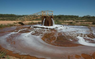
Beneath those coastal flats lay sulfide-rich sediments deposited in waterlogged estuaries thousands of years ago. As long as they remained wet, they were mostly inert. When exposed to oxygen through drainage, excavation, or falling water tables, they altered their character. Iron sulphides oxidised, and sulfuric acid formed. Metals were mobilised, and the damage did not stay confined to the paddock; it spread into drains, creeks, estuaries, concrete, steel, and fisheries.
This is the story behind the Byron Local Environmental Plan 1988: the moment a concealed soil chemistry issue became evident enough to influence planning law.
Before the law came the shock
Acid sulphate soils are hard on legal systems because the chain of harm is complicated. The cause is hidden underground. The trigger may seem routine. The damage might occur elsewhere entirely. A drain is dug here, a water table drops there, and downstream a river or wetland begins to fail.
Law prefers things it can see and separate: a pipe, a discharge, a clearing, a boundary line. Acid sulphate soils refuse that neatness. They turn earthworks into water pollution and planning decisions into chemical consequences.
By the late twentieth century, that refusal was impossible to ignore. Coastal management could no longer pretend the problem was merely poor farming practice or an isolated engineering error. The soil itself had become an active part of the story.
Robert Quirk
This is where sugarcane farmer Robert Quirk plays a crucial role. His livelihood depended on understanding the chemistry beneath his feet. Collaborating with scientists Mike Melville and Ian White, he helped shift the focus from merely treating symptoms to managing the hydrology that drove the problem.
The lesson was simple and humbling. If exposing pyrite caused acid, the first task was not to dominate the soil more aggressively, but to stop provoking it. This meant filling in miles of unnecessary deep drains and laser-levelling the cane fields to shed surface water without lowering the water table. Keep the soil wet. Minimise unnecessary deep drainage. Alter how water moves across the land.
The reversal is striking. Improvement had meant drainage, exposure and control. Recovery relied on restraint.
When planning law finally noticed the soil
Byron Local Environmental Plan 1988 marks the point at which that knowledge began to take legal form.
The most striking feature was not rhetorical. It was practical. Clause 63 established an acid sulphate soils planning regime built around mapped risk classes. Even relatively modest works could require attention to whether disturbing the ground would trigger acidification. Planning had been forced to admit that some soils were not neutral building platforms.
That may sound technical. It was a legal shift. To make acid sulphate soils a matter for planning law was to accept that development could activate a hidden environmental hazard buried in the land itself. The problem was no longer only what one intended to build. It was what one might unleash by digging, draining, filling or lowering water levels.
Soil had become legally visible.

Soil risk classes under the Byron Local Environmental Plan (LEP) 1998, Australia NSW.
Conclusion: More than a local planning story
This story shows how environmental law often evolves. Rarely does the law start with a calm recognition of ecological complexity. More often, it is dragged there by a landscape that begins to fail in public.
Acid sulphate soils are a particularly stark example because they sit at the intersection of soil, water, infrastructure, and time. A planning decision today can trigger chemical consequences rooted in sediments thousands of years old. The law comes into play too late.
This is what makes it a story about soil security. While soil security is straightforward to acknowledge in principle, it is more challenging to incorporate into law. Usually, soil becomes visible only after disturbance, which then threatens the things people already value.
It also shows what good soil law can, and cannot, achieve. Byron LEP 1988 is strongest where it emphasises caution: it maps out risks, classifies danger, and forces planning systems to pause before causing disturbance. It is based on evidence-based and knowledge-enhancing. However, it also reveals the limitations of recognition. A law can identify a soil threat and still leave the tougher questions of duty, restoration, and stewardship unresolved. Soil security is still too often codified in the muddied aftermath of failure. The law learns only after the river turns blue.

by Julio Pachón Maldonado
Postdoctoral Research Associate in Soil Security
Julio Pachón Maldonado is a soil scientist whose work centres on soil security, particularly the dimensions of Connectivity—people’s awareness and engagement with soils—and Codification—the legal and policy frameworks that protect them. He has collaborated with stakeholders across Europe, Africa, South America, North America, and Australia, combining field-based pedological experience with advances in digital soil mapping and policy analysis. His current focus is on self-assessment tools that allow farmers, policymakers, and land managers to connect directly with the latest soil research in a personalised way, while also exploring how artificial intelligence can assess legislation and strengthen governance frameworks that bring soils into global sustainability debates.
Related Articles

23rd World Congress of Soil Science 2026: Connecting Science to Policy in Nanjing
Earlier this month, the global soil science community converged on the Nanjing International Expo Centre for the 23rd World Congress of Soil Science (WCSS). Hailed as the “Olympics of Soil Science”, this marks the first time in the event’s nearly 100-year history that...

How Spectroscopy Secures Soils Assessing Soil Capacity (Quality) and Condition (Health)
Photo of Ho Jun Hang from The University of Sydney Soil is far more than just "dirt." It is a living ecosystem critical for food security, water security, and climate regulation. However, traditional laboratory soil analysis is often slow, expensive, and...
The Ghost in the Machine: How an Ancient Ocean Rewrote Australian Law
On January 23, 1830, Charles Sturt reached the junction of the Murray and Darling rivers in south-western New South Wales. For the British Empire, it was a cartographic success. For Sturt, it carried a familiar bitter taste. A year earlier, further north, he had found...