From Aerial Photography to Satellites: How Tech Is Securing Our Soil
A Vision.
As Vikram Sarabhai, founder of India’s Space Agency, once said:
“There are some who question the relevance of space activities in a developing nation. To us, there is no ambiguity of purpose. We do not have the fantasy of competing with the economically advanced nations in the exploration of the moon or the planets or manned space-flight.”
“But we are convinced that if we are to play a meaningful role nationally, and in the community of nations, we must be second to none in the application of advanced technologies to the real problems of man and society.”
His words remind us that the goal of remote sensing is not just about satellites or technology — it’s about using advanced tools to solve real problems and Soil Security is 100% a real problem.
What Is Remote Sensing?
A widely used definition, given by Jensen (2007) (who cites Colwell, 1997), describes remote sensing as:
“the art, science, and technology of obtaining reliable information about physical objects and the environment, through the process of recording, measuring and interpreting imagery and digital representations of energy patterns derived from noncontact sensor systems.” (Colwell, 1997)
In simple terms, it’s about using sensors — often on satellites or aircraft — to study the Earth without having to touch it directly.
How it works?
Satellite sensors measure the electromagnetic radiation (like light or heat) that is reflected, emitted, or sent back from the Earth’s surface. This energy acts as a surrogate for what we really want to understand — whether it’s the condition of soil, the type of land cover, or the size of a flooded area.
The data collected across different wavelengths is then turned into useful information using mathematical methods. This makes remote sensing a powerful scientific tool for monitoring our soils and our planet in general. (Jensen ,2007)
From Balloons to Satellites: A Quick History
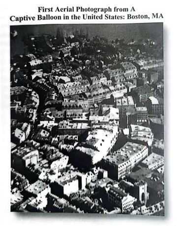
The first aerial photograph was taken by James W. Black and Samuel A. King from a tethered balloon at an altitude of 1,200 feet over Boston on October 13 (shown in Figure 1).

Figure 1. The first aerial photograph, taken by James W. Black and Samuel A. King from a tethered balloon (scanned from Jensen 2007).
Systematic aerial photography began during World War I, when it was developed for military surveillance and reconnaissance. After the war, this technology quickly found new uses in civilian and scientific applications, laying the foundation for today’s remote sensing (Jensen, 2007).
Remote sensing has come a long way since those early black-and-white aerial photos of World War I. Advances in technology have transformed simple images into detailed, multi-layered data. Today, satellites carry multispectral, hyperspectral, and radar sensors that capture visible light, infrared energy, and surface signals in different ways.
- Multispectral sensors collect data in a few broad bands (like red, green, blue, near-infrared, and thermal infrared).
- Hyperspectral sensors collect much more detailed data in dozens or even hundreds of narrow bands, helping us detect subtle changes in soil and vegetation.
- Radar sensors work differently — they send out signals and measure how they reflect off the ground, which helps monitor surface features, land movement, and even soil moisture.
This technology allows scientists to track soil conditions, vegetation health, water quality, and more — giving us a clearer view of the Earth than ever before.
How Satellites Help Secure Our Soils
Satellites play a key role in protecting and managing soil condition. By capturing visible, infrared, and radar data regularly over time, they enable scientists to build time-series analyses that show how soils change seasonally or year after year. This makes it possible to spot trends like erosion, declining soil moisture, salinity, or land degradation before they become serious problems.
This ongoing flow of information helps farmers, policymakers, and conservationists make better decisions to keep soils healthy, prevent damage, and restore degraded land. The technology keeps improving and becoming more affordable, with high-resolution sensors and nanosatellite constellations (like Planet Labs) now delivering near-daily data with global coverage. Improved computing power also means we can process huge datasets faster, making it possible to monitor soil and land changes almost in real time.
Conclusion: From Aerial Photography to Ground-Level Action
From early aerial photography to modern satellites — remote sensing has evolved into an essential tool for soil and environmental monitoring worldwide.
Today’s multispectral, hyperspectral, and radar sensors provide detailed, continuous information that helps detect soil degradation, erosion, salinity, and other threats before they become severe.
Remote sensing technologies are becoming more affordable and accessible, with constellations of nanosatellites delivering near real-time data with global coverage.
By combining different remote sensing technologies with field soil surveys for ground truthing, we can make smarter decisions to secure, restore, and sustainably manage our soils.

by Nicolas Francos
Postdoctoral Researcher, Soil Security Laboratory, The University of Sydney
Nicolas is a Postdoctoral Research Associate at the School of Life and Environmental Sciences and the Sydney Institute of Agriculture (SIA). His current research focuses on soil security and the development of methods for estimating soil organic carbon sequestration using spectroscopy and remote sensing techniques. He completed his Bachelor's degree in Geography at the Hebrew University of Jerusalem and both his Master's and PhD at Tel-Aviv University. His graduate research focused on soil spectral modelling at various scales, ranging from laboratory analyses and field studies to remote sensing, utilizing both hyper- and multi-spectral resolutions from aerial and satellite imagery, combined with extensive field campaigns for ground truthing.
